This page is about abandoned proposals to incorporate the A20 into an urban motorway network for London, not about the road as it exists today.

It might have been the least noticed and least controversial of London's urban motorway plans, a collection of odd jobs and quick wins. But most of it was never built.
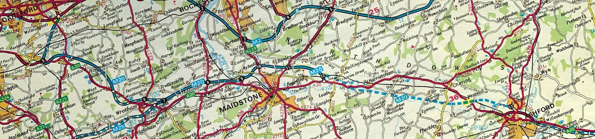
The A20 stretches from New Cross in south east London to Dover, the second of London's two major roads to travel the length of Kent and offer a gateway to continental Europe. In the 1960s, planners envisaged it as a part of London's Primary Road Network - its urban motorways, in other words - beginning on Ringway 1 at Kidbrooke and heading out to the new M20 east of Swanley.
Three separate projects would see it finished. Within London, the Greater London Council were going to build the Sidcup Link, a short motorway attached to the A2(M) Dover Radial Route project, from Kidbrooke to Mottingham. A second project, the A20(M), would extend the motorway from Mottingham to the limit of the GLC's responsiblity at Kemnal Corner.
The third project was a trunk road scheme drawn up by the Ministry of Transport. They would upgrade the 1920s Sidcup Bypass, providing a modern near-motorway road around Sidcup and a direct link to the Swanley Bypass. From there, the Swanley Bypass had opened in 1966, designed almost to full motorway standards and flowing directly into the M20.

None of those three projects were very demanding, compared to the ambitions for London's other motorways, and none seemed particularly controversial. What's more, all three were so far along the planning process that, by the time of the Greater London Development Plan Inquiry, it was hoped that work would be starting in a few short years.
That could have seen the A20-A20(M) approach to London substantially completed at an extremely early date, one of London's problematic new roads ticked off the list without much bother.
In the end, it wasn't trouble with these roads that saw them off, but trouble with plans for roads in general. The wholesale trashing of the GLDP's vast plans for new roads saw the A20 schemes thrown aside. Work on the Sidcup Bypass was eventually resurrected in the 1980s as part of preparations for the Channel Tunnel, but the rest is now just one of the most obscure and most forgotten unbuilt roads in London.
Outline itinerary
![]() R1 East Cross Route, R1 South Cross Route and A2(M) (Kidbrooke Interchange)
R1 East Cross Route, R1 South Cross Route and A2(M) (Kidbrooke Interchange)
![]() A210 Eltham Road, A205 Westhorne Avenue (Eltham Green Interchange)
A210 Eltham Road, A205 Westhorne Avenue (Eltham Green Interchange)
![]() R2 Eastern Section and R2 Southern Section (Dutch House Interchange)
R2 Eastern Section and R2 Southern Section (Dutch House Interchange)
![]() B263 Green Lane (Fairy Hill Interchange)
B263 Green Lane (Fairy Hill Interchange)
![]() A222 Chislehurst Road (Frognal Corner Interchange)
A222 Chislehurst Road (Frognal Corner Interchange)
![]() A224 Sevenoaks Way (Crittals Corner Interchange)
A224 Sevenoaks Way (Crittals Corner Interchange)
![]() B2173 Maidstone Road
B2173 Maidstone Road
![]() R3 Eastern Section and R3 Southern Section (Swanley Interchange)
R3 Eastern Section and R3 Southern Section (Swanley Interchange)
![]() Continues to Maidstone and Ashford
Continues to Maidstone and Ashford
Cost summary
| Property acquisition (1970) | £4,600,000 |
| Rehousing (1970) | £600,000 |
| Construction (1970) | £40,625,000 |
| Environmental works (1970) | £63,000 |
| Total cost at 1970 prices | £45,888,000 |
| Estimated equivalent at 2014 prices Based on RPI and property price inflation |
£196,046,060 |
See the full costs of all Ringways schemes on the Cost Estimates page.
Route map
Scroll this map horizontally to see the whole route

Key to map symbols
| "Primary Road" Network | |
|---|---|
| Primary Road | |
| Primary Road section in tunnel | |
| Primary Road approximate or assumed line | |
| Primary Road cancelled or deleted before start of GLDP Inquiry | |
| "Secondary Road" Network | |
| Secondary Road single carriageway or of unknown formation | |
| Secondary Road known to be dual carriageway | |
| Secondary Road section in tunnel | |
| Junctions | |
| Location of Primary Road junction where layout is not known | |
| Location of Secondary Road junction where layout is not known | |
| Location of a junction cancelled or deleted before start of GLDP Inquiry where layout is not known | |
Route description
This description begins at the north-western end of the route and travels south-east.
Kidbrooke to Sidcup
At Kidbrooke, Ringway 1's East Cross Route would pass beneath the four-level junction, and sliproads would converge to form a three-lane motorway heading south. The junction would provide access to the South Cross Route and the A2(M).
A vacant corridor was reserved for the motorway down the east side of the Ferrier Estate, a huge complex of council tower blocks built by the GLC between 1968 and 1972, though it has since been demolished and the corridor built on when the estate was redeveloped in the 2000s.
The motorway would run through the eastern edge of Sutcliffe Park before passing below the A210 Eltham Road and A205 Westhorne Avenue. An interchange would be provided here, with access to and from the north only, though its layout is uncertain because the only designs that exist were ruled out at the planning inquiry.

Continuing south through the Civil Service playing fields, the motorway would reach Dutch House Interchange, with connections to Ringway 2's Southern Section. It would then turn east, in a cutting on the north side of the A20 Sidcup Road, first through open ground and then by demolishing all the houses between the road and railway.
At Court Road, the motorway would cross to the south side of the A20. A roundabout interchange would be provided here, though no plans of its exact layout have come to light. The motorway would then follow the south side of the A20, still in cutting, requiring the clearance of all the houses along the road, until reaching open ground at Kemnal Corner and the start of the 1920s-era Sidcup Bypass.
Sidcup to Swanley
At Kemnal Corner, the A20 crosses the former London County Council boundary, and became a trunk road. As a result, the GLC's A20(M) would have connected with the Sidcup Bypass here, and beyond this point plans were in the hands of the MOT.
The Sidcup Bypass would have been widened to a three-lane dual carriageway and provided with flyovers and underpasses at its junctions. The road that exists today is a product of the late 1980s, and smaller in scale than the plans that would have been developed in the early 1970s, but gives an idea of what might have been planned. An offline section would run from the A224 Sevenoaks Way to the start of the Swanley Bypass, taking the A20 around Ruxley and the junction of the A223.

An interchange with the B2173 would follow as the A20 joined the Swanley Bypass itself, a dual three-lane road with hard shoulders. It hints at the type of road that may have been provided for the Sidcup Bypass too. The Swanley Bypass travels around the south side of the town to reach Swanley Interchange, providing connections with Ringway 3's Eastern Section and Southern Section. Here, the A20 would flow into the M20 towards Maidstone, which in turn would meet the far end of the Ringway 4 South Orbital Road at Wrotham.
A quick fix
When the London County Council's planners began seriously thinking about motorways in London, the A20 wasn't high on their list of things to do. It was a reasonably good road already - a dual carriageway from Eltham to the council boundary at Kemnal Corner, albeit one interrupted by roundabouts and lined with houses. Further out, the Ministry had opened the Sidcup Bypass in 1926, and work was starting on the Swanley Bypass.
When the GLC took over in 1965, their responsibility for the A20 didn't extend any further than before, but their ambitions certainly did. The A20 would tie in to London's new urban motorways. Since the distance concerned was very short, they hoped to build it in two sections, each of which was really a footnote in a bigger road project nearby.
The first upgrade would come with the A2(M) Dover Radial Route, a project that went to public inquiry in 1967 - of which, more in a moment. It was a bypass for the A2, but at Kidbrooke it would turn a corner at a part-built interchange that would ultimately form the south eastern corner of Ringway 1. Heading south from that junction would be a spur connecting it to the A20 at Mottingham, known as the Sidcup Link.

This would be a motorway, with a north-facing junction at the Yorkshire Grey Roundabout linking to the A205 and A210, and it would end on the existing A20 at Mottingham. It would link the A20 to the Blackwall Tunnel via the brand new East Cross Route, and form the first link in the upgrade of the A20.
The Dover Radial Route was approved at public inquiry and work was due to start on the ground in 1970 or 71, so the Sidcup Link seemed certain to go ahead. Work was only waiting while the Greater London Development Plan Inquiry took place.
The rest of the A20 under GLC control was less than three miles long. In July 1969, plans to replace it all with a parallel dual three lane urban motorway called the A20(M) were published - but they were almost entirely ignored because they were tacked on to the monster project of Ringway 2's Southern Section, an unbelievably destructive motorway so controversial that the GLC's road plans never really recovered from the fallout. In its shadow the little A20(M) barely registered.
Expected to be built at the same time as the adjoining section of Ringway 2, the A20(M) would extend the Sidcup Link east until it reached open ground at Kemnal Corner. There, the new road would find the MOT's planned upgrade for the Sidcup Bypass, and the two would flow seamlessly together.

No start date was ever set for Ringway 2 in this area, or its little brother the A20(M), but around 1970 the GLC expected it to fall within Phase II of the road plans, meaning the 1980s, and since a high priority was attached to the completion of Ringway 2 it would probably have come early in that period.
Since the Ministry's plans for the Sidcup Bypass were projected for the mid-1970s, the Sidcup Link was expected to be open by 1973, and the Swanley Bypass was finished in 1966, that would have got the A20 over the finish line sooner than most other new roads in London, and with almost no fuss.
Almost.
Absolutely loopy
The planning inquiry into the Dover Radial Route and the Sidcup Link took place in 1967 and approved almost the whole scheme. It seems remarkable now, but this project for a complex urban motorway through affluent London suburbia attracted little controversy - except at the Yorkshire Grey.

The Sidcup Link's design involved a three-lane motorway passing under the A205 and A210. The roundabout connecting those roads would be replaced with a far larger pentagonal one, with much of the housing west of the roundabout demolished, and a pair of sharply looped sliproads would link the motorway with the roundabout.
The roundabout is named for the Yorkshire Grey, a building that stands on its western corner, and that was a problem. One local newspaper set the scene.
South-east London's top banqueting hall, the Yorkshire Grey Ballroom, together with the adjoining hotel, faces demolition if the G.L.C.'s latest addition to its plans for the Dover radial route motorway and its link-roads across Eltham go through.
The ballroom and hotel are not only the focus of much social life locally, but the Yorkshire Grey is a famous and long-established landmark.
Locals were unhappy, but the owners of the ballroom, a brewery called Ind Coope, were even more aggrieved. They were determined to save their most famous pub (it was, let's be honest, a pub) and hired the best planning lawyer they could find to represent them at the public inquiry. His name was Mr Frank Layfield.
Planning officials were unlikely to have enjoyed the disparaging examination of their motorway plans delivered by Mr Layfield, but they could probably never have imagined that, just three years later, he would come back to haunt them when the Government chose him to preside over the inquiry that would scrutinise the whole of the Greater London Development Plan. His work on the Yorkshire Grey was only the start of his long and critical association with London's motorway plans.
Thanks, in part, to Layfield's testimony, the inspector agreed that the Yorkshire Grey junction had to be redrawn. The road plan was approved, conditional on the GLC finding a way to save the ballroom, banqueting hall and boozer on the roundabout.

Unfortunately no other design for the junction has survived, so the original plan appears on the map at the top of this page, even though we now know it would never have been built. But South London's top banqueting hall was saved. It's now a McDonald's.
Under the radar
The rest of the A20(M) was an urban motorway some 3.6km (2.2 miles) in length to be built almost entirely by demolishing semi-detached suburban houses. In part, at its western end, the short length where it ran parallel with Ringway 2 would call for more space than was available on one side of the A20, so there the houses on both sides of the road would be demolished and the existing road moved too.
Anywhere else, at almost any other time, this would have been a project that made headlines. But the A20(M) was just a trailer hitched to the express train of destruction called Ringway 2, and it nearly went unnoticed.
Because it was part of a bigger plan, there are surprisingly few references to the A20(M) from the days when it was an active road proposal: even at County Hall, it was easily overlooked. It's missing from most documents outlining timescales and priorities for the Ringways network, and its demise has to be inferred from its absence after the GLC's new Labour administration arrived in April 1973 and cancelled the motorway plans.

Certainly the Sidcup Link bit the dust when the Dover Radial Route project was abandoned as part of that huge u-turn. And without the Sidcup Link the A20(M) made no sense: a dual three-lane motorway that would dump all its traffic onto the existing A20 Sidcup Road on the final approach to Clifton's Roundabout.
Intriguingly, though, its name did survive a little bit longer. After the Greater London Development Plan was finally published in 1976 - stripped of its motorways - the GLC were required to investigate improvements to orbital journeys around South London where Ringway 3 would have run. A study was duly made, in which the GLC investigated dualling existing roads from the A20 at Sidcup to the proposed M23 at Carshalton.
It was a terrible plan, and went no further, but weirdly, the drawings of the Sidcup end show it terminating on a road called the A20(M). No further reference to it has ever been found.
A storm in a Sidcup
In the late 1970s, one or two maps were published where the M20 is shown with the wrong junction numbers. At that time, the motorway began at Swanley, where it does now, and ended at the eastern side of Maidstone. But where Swanley is junction 1 today, the maps mark it as junction 5.
It's cropped up more than once, so it's unlikely to be an error. It looks rather like the Department of Transport changed their minds about junction numbering at a late stage, and the first draft would have left space for four more numbered junctions.
To extend the motorway west from Swanley towards the proposed A20(M) wouldn't have been hard. The Swanley Bypass was relatively new at the time, and is built almost to full motorway standards. It could have become the M20 without much fuss.
There would then remain the Sidcup Bypass, a 1920s arterial road with some notorious roundabouts on the way. The plans drawn up by the Ministry seem not to have survived, but a 1970 internal report said the intention was to "bring the route up to a dual three lane standard with grade separation compatible with the standard now to be found on the quite recently constructed Swanley Bypass". That would make it, at the very least, something close to motorway standard.
Whether or not the M20 would ever have been extended west is pure speculation. Those four spare junction numbers only seem to be enough to reach the point where the GLC take over responsibility, so it looks unlikely that the M20 would be pushed right the way in to Kidbrooke. But it does seem certain that, whether the signs were blue or green, the road from Swanley to Ringway 1 would have been a continuous three-lane road of a very high standard.

Sidcup's bypass never got its motorway-standard upgrade, but it did get a very serious improvement to two-lane expressway standard, opening in 1987. The new road meets the Swanley Bypass head-on, so three lanes arbitrarily narrow down to two on the way in to London. But it is still a very high standard of road, meaning that - eventually - the trunk road section of A20 got nearly everything that was promised, while the GLC's length from Kidbrooke to Sidcup remains virtually unchanged despite all their grand plans.
Picture credits
- Route map contains OS data © Crown copyright and database rights (2017) used under the terms of the Open Government Licence.
- Sketch of A20(M) and cross-section diagram are extracted from HLG 159/2508.
- Photograph of Sidcup Road is taken from an original by David Hallam-Jones and used under this Creative Commons licence.
- Photograph of Swanley Bypass in 1966 is © Canadian Centre for Architecture and used under licence.
- Scheme plan of DRR and Sidcup Link extracted from GLC/DG/PTI/P/05/031.
- Engineering plans of Eltham Green junction and Sidcup Link extracted from CRES 65/191.
- Photograph of Yorkshire Grey is taken from an original by David Anstiss and used under this Creative Commons licence.
- Photograph of Robert Vigars appeared in the Daily Telegraph, 18 July 1969.
- Extract of map showing M20 with different junction numbers is taken from Bartholomew's Motorway & Town Plan Atlas (1978) and used under fair dealing rules. This scan appears courtesy of Geoff Rimmer.
- Photograph of A20 at Frognal Corner is taken from an original by David Martin and used under this Creative Commons licence.
Sources
- A20 forming part of PRN only between Kidbrooke and Swanley; route corresponding to existing A20 east of Kemnal Corner: GLC/TD/C/P/02
- Layout of Kidbrooke Interchange; route, Kidbrooke-Mottingham (Sidcup Link); Sidcup Link as component of 1967 Dover Radial Route scheme; work expected to start 1970/71; Yorkshire Grey junction layout and planning controversy: CRES 65/191
- Route, Mottingham-Kemnal Corner: HLG 159/2426; HLG 159/2508
- Sidcup Bypass opening 1926: MT 39/511
- A20(M) as component of Ringway 2 Norbury-Falconwood scheme: HLG 159/2390
- Swanley Bypass open 1966; Sidcup Bypass and Ruxley Bypass improvements open 1987: A20 Improvements Timeline, SABRE Wiki.
- Reference to A20(M) in 1976 orbital movement study: GLC/TD/PM/CDO/06/027
